| | main | kilauea | order | win tec | mac tec | staff | |
|
eruption section |
Explore Kilauea Volcano
|
Highlights
Navigate eight clickable timelines chronicling the origin of the Earth
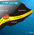
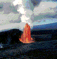
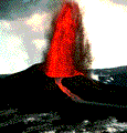
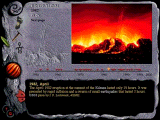
up to the most recent eruptions of Kilauea. Watch how volcanos built the Hawaiian island chain. See hundreds of photographs, animations and illustrations. View stunning video of lava fountains and flows. The Pu`u Pua`i Vent erupting in 1959. Film courtesy of USGS. Download now (825K) The Mauna Ulu eruption began as a fissure between `Alo`i and `Alae craters in 1969. Film courtesy USGS. Download now (384K) The Pu`u `O`o eruption beginning in 1983. Lava fountains rose 100-165 feet above the surface of the lava lake. Video courtesy USGS. Download now (875K) Lava fron the current eruption of Kilauea enters the ocean near Kamokuna. Video by M. Kuetemeyer & A. Shetty. Download now (1750K) Evolution of Kilauea During the Last 10,000 Years10,000 years ago What did Kilauea look like 10,000 years ago? It certainly had a summit, an East Rift Zone, and a Southwest Rift Zone. There may (or may not) have been a caldera. The slides start with a grossly simplified map that shows a single unit of rocks 10,000 years old or older. There were certainly lava flows and tephra of very different ages. Because nearly all of these rocks are buried it is difficult to know much about them. Geologists know much more about the last 10,000 years of Kilauea. Historic Eruptions 1790 About 200 years ago, as Kilauea caldera formed, large volumes of ash erupted at the summit and lava erupted on the lower east rift zone. The ash blankets the summit of Kilauea volcano. Part of the caldera probably formed during this eruption. Collapse to produce the caldera was the result of magma withdrawing from the chamber 3-6 miles (2-4 km) below the summit. 1879-80 "Both lakes very active, Halema`uma`u throwing jets of lava up at least fifty feet above the rim of lake so often that the lake looks like a fountain of fire from the verandah." W. H. Lentz, 24 June 1879. From the Volcano House Register. 1881 "Saw again this night the incomparably beautiful appearances of brightenings of this place with the fires like lanterns lighting up and staying a while here and there in the crater. In the sketch are the new fire lake and the lakes of Halema`uma`u and Kilauea close by, and looking at the eruption on Mauna Loa." [Translated from Hawaiian.] Joseph Nawahi, Emma A. Nawahi, Mihana Aii, 21 Feb 1881. From the Volcano House Register. Pre-1924 "I visited the crater. The scene was very different to that presented on my previous visit (December 1905). At that time the lava was about 600 feet below the brink and scarcely alive, fire being sometimes visible through the thick smoke, but never to any extent. Today the lava has risen to probably less than 150 feet from the top and is in constant motion throughout most of the mass." G.W. Kirkaldy, Honolulu, 18 April 1908. From the Volcano House Register. 1924 On May 10, 1924, a phreatic eruption was triggered by a rapid drop in the level of a long-lived lava lake within Halema`uma`u. This allowed ground water to come in contact with hot rock and cause violent explosions. 1924 After the 1924 eruption the Halema`uma`u Crater was 1,335 feet (410 m) deep. Between July 1924 and October 1934 seven eruptions intermittently filled the crater. These eruptions lasted only 2-33 days. Kilauea did not erupt again until 1952 Recent Eruptions 1952 Halema`uma`u The 1952 eruption of Kilauea was at Halema`uma`u and lasted 136 days. It marked the onset of the current cycle of activity that includes a shift to the East Rift Zone at the main location of eruptive activity. 1955 East Rift Zone With the exceptions of two eruptions that lasted less than one day, Kilauea had not erupted on its East Rift Zone since 1840. This changed on the morning of February 28, 1955, when a line of fissures opened across the Pahoa-Pohoiki Road. 1959 Kilauea Iki Eruption The Kilauea Iki eruption began on the morning of November 14, 1959, three months after a rapid increase in inflation of the ground surface and the number and size of earthquakes. The eruption started halfway up the 600-650 foot (180-200 m) south wall of the crater as a curtain of fire a half-a-mile (0.8 km) long. As the eruption continued, lava poured down the wall of the crater, the lava lake grew larger and deeper, and both the rate the lava extruded from the vent and the size of the lava fountain increased. The first phase of the eruption continued for seven days, until the crater was half-filled with lava and the level of the lava lake reached the height of the vent. During the second phase of the eruption, lava spilled from the lava lake in the deeper east crater and began to flow into the west crater. After many eruption episodes the unstable walls of the growing cinder cone collapsed into the lava lake. The eruption continued for 4 more weeks and included 16 additional eruptive phases. Each eruptive phase produced a lava fountain. The views of the fountain and lava lake at night were spectacular. The Kilauea Iki eruption was, at that time, the most detailed study of eruptive activity ever at a Hawaiian volcano. Earthquakes, volcanic tremor, tilting of the ground, rate of lava extrusion, lava fountain height, and the temperature, chemistry, and petrography of the lava were recorded almost continuously. These methods are still used today to predict eruptions and to better understand the inner workings of volcanoes and how they erupt. 1960 Kapoho Following the 1959 summit eruption at Kilauea Iki, an eruption commenced on January 13, 1960, on the lower East Rift Zone near the town of Kapoho. The eruption lasted 36 days and buried about 2 square miles (5.6 square km) of land including most of the town of Kapoho. 1961-65 Halema`uma`u Three eruptions occurred at Halemaumau in 1961. The longest eruption lasted only 22 days. Activity returned to East Rift Zone in 1961 with an eruption that lasted only 3 days. Five more eruptions occurred on the East Rift Zone between 1962-1965. Most of these eruptions lasted only 1-2 days. 1967-1968 Halema`uma`u Since the 1924 explosive eruption, Halema`uma`u has been gradually filling with lava from numerous short-lived eruptions. The longest of these eruptions lasted about eight months from 1967-1968. It was the longest-lived lava lake at Halema`uma`u since 1919. It is also the most recent year that a long-lived lava lake has occupied Halema`uma`u. 1967 - 1968 Halema`uma`u and East Rift Zone Activity returned to the East Rift Zone on August 22, 1968. The eruption lasted 5 days and produced lava at numerous vents scattered 12 miles (20 km) down the rift. In October of 1968 an eruption near Napau Crater lasted 15 days. 1969, May 24 Prior to the Mauna Ulu eruption, Chain of Craters Road continued east to Makaopuhi Crater and down to the coast. It passed `Alo`i and `Alae, two pit craters, and Pu`u Huluhulu, a pre-historic cinder and spatter cone. The Mauna Ulu eruption began on May 24, 1969 and ended on July 22, 1974. Kilauea Volcano had erupted for nearly 5 years at a vent on the East Rift Zone of the volcano. This was the longest flank eruption of a Hawaiian volcano in historical time (a record that has been broken by the current eruption). It dramatically changed the landscape by covering large areas with lava, filling two pit craters, constructing a new vent, and adding land onto the island. 1971, August In August of 1971, Kilauea erupted from fissures in and along the southeast part of the caldera. Although this eruption was only 10 hours long, it was very spectacular, generating fountains up to 250 feet (75 m) high, lava cascades, and lava flows that covered nearly one-fifth of the caldera floor. Lava is moving away from the fissures to the north (top left corner). 1971, September In September of 1971, an eruption began on the floor of the caldera and migrated into the southwest rift zone. It was the first eruption on this rift since 1921. The eruption lasted five days producing lava fountains, cascades of lava into Halema`uma`u, flows which crossed the road, and new cracks in the rift zone. 1972 Mauna Ulu Following a six month hiatus in eruption, activity resumed at Mauna Ulu in February 1972. Like the previous period of continuous activity, lava traveled in a tube from the lava lake at the summit of Mauna Ulu to a lava lake at the location of `Alae Crater. Overflows of this lava lake built a second shield adjacent to Mauna Ulu. 1973 - 1974 Mauna Ulu and Pauahi Crater Unlike the current eruption, where the active vent is in a remote location, the vent for the Mauna Ulu eruption was accessible. Park visitors could stand on the edge of the vent and peer into a lava lake. In April of 1973, a magnitude 6.3 earthquake occurred on the island of Hawai`i. This earthquake apparently caused changes in the plumbing system of Kilauea Volcano. Lava drained from Mauna Ulu and an eruption began at Hi`iaka and Pauahi craters. Lava returned to Mauna Ulu two days later but activity was sluggish. 1973, May Fissure eruptions in 1968 and 1973 produced lava flows in and around Hi`iaka Crater. The 1968 eruption lasted less than one day and formed a small lava pond on the crater floor. The 1973 eruption also lasted less than one day but was far more dramatic. Fissures opened on the south side of the crater floor, in the collapse basin, and just outside of the crater. 1973, November Lava from some of the fissures cascaded 300 feet (100 m) to the floor of Pauahi Crater. After the initial flurry of activity, a single vent in the western pit crater continued to erupt. Lava in the central pit had drained, leaving behind a "bath tub ring" that marked the high stand of the lake. Late in 1973 and continuing into 1974, the intensity of activity increased. The lava lake overflowed and lava fountains reached heights of 250 feet (80 m). In this period whirlwinds ripped hot crust from the surface of the Mauna Ulu lava lake. Over a month-long period, 5 episodes occurred, generating fountains and flows. Most flows went north and ponded between Mauna Ulu and Pu`u Huluhulu. Some flows went westward and covered Pu`u Huluhulu trail, rebuilt after the 1973 eruption. On the 25th, the end of the flow had turned to `a`a and reached the end of Chain of Craters Road. The strong eruptive activity ended on the 26th. Methane explosions occurred as far as 150 feet in front of the advancing flow margin. 1974 Summit Caldera and Southwest Rift Zone The Mauna Ulu eruption ended on July 19, 1974. Lava drained from the vent and the summit of Kilauea deflated. A short time later an eruption began at Keanakako`i Crater. 1974, July Kilauea erupted again in July of 1974 from fissures in the Keanakako`i area and the south part of the caldera. Prior to the eruption, tilt at the summit decreased rapidly and tremor increased sharply. Lava covered the floors of Keanakakoi and Lua Manu craters. Lava from the fissures cascaded over the rim of the caldera and nearly buried all of the flows from the August 1971 eruption. The lava moved north in a natural moat that rings the caldera. The moat is a result of the more frequent eruptions near Halema`uma`u that built that area higher. The eruption lasted about three days. 1974, September History repeated itself in September of 1974. Again, an eruption began on the floor of the caldera and migrated into the southwest rift zone. The eruption lasted four days and covered much of the lava erupted in 1971. 1975 South Flank On November 29, 1975, a magnitude 7.2 earthquake occurred on the south flank of Kilauea. It was the largest earthquake in over a century. The movement of the south flank during the earthquake generated a tsunami. Two people were killed by the tsunami. The earthquake caused over $4 million in damage. The earthquake also triggered an eruption that lasted less than a day from a fissure just east of Halema`uma`u. 1977 East Rift Zone Activity returned to the East Rift Zone on September 13, 1977. The eruption last 18 days and sent flows 5 miles (8 km) down the flanks of the volcano. 1979 Hi`iaka Crater The most recent eruption at Hi`iaka Crater on the East Rift Zone was on November 16, 1979. The eruption was preceded by a swarm of earthquakes that lasted 11 hours. The eruption began from a fissure on the floor of the crater. As the eruption progressed, a new fissure formed just northwest of the crater and produced lava flows which traveled to the south. 1982 Summit Caldera The April 1982 eruption at the summit of the Kilauea lasted only 19 hours. It was preceded by rapid inflation and a swarm of small earthquakes that lasted 3 hours. Lava erupted from a fissure and produced a curtain of fire 15-30 feet (5-10 m) high. The second eruption in 1982 began on the evening of September 25 and lasted only 15 hours. Curtains of fire developed above fissures. This was the most recent summit eruption of Kilauea volcano. Two fissures formed in the southern part of Kilauea caldera and sent lava flows to the northwest and south. The northwest flow crossed Crater Rim Drive and spilled into the caldera. Volcanologists on duty during the eruption reported feeling several dozen earthquakes. 1983 Middle East Rift Zone - Start of the current eruption On the early morning of January 2, 1983, the summit of Kilauea began to deflate, and the number and size of earthquakes increased in the volcano's east rift zone. The earthquakes started near Mauna Ulu and migrated east to Napau Crater and Pu`u Kamoamoa. Geologists interpreted the swarm of earthquakes to be a result of magma breaking rock as it is forced into the rift zone and then moved towards the surface. Shortly after midnight on January 3, 1983, lava was sighted near Napau Crater. Seismic instruments also recorded an increase in the amount of harmonic tremor, the earthquake pattern that indicates magma movement and eruption. Over the next nine hours, a discontinuous line of the eruptive fissures extended 4 miles (6 km) down the rift. Near the end of this activity the eruption became concentrated in the vicinity of Pu`u Kamoamoa. The photograph shows a line of fissures about 0.9 km long. 1983-1986 Pu`u `O`o For 65 days following Episode 3, the volcano was quiet. On the morning of June 13, the level of tremor began to increase. By late morning, a line of discontinuous fountains 65 to 130 feet (20-40 m) high and 330 to 490 feet (100 to 150 m) long formed down rift from Pu`u Kamoamoa. The locus of major fountaining was at the "O" vent, a 65 foot (20 m) high spatter cone. The cone enclosed a crater that contained a lava lake (Wolfe and others, 1988). At this time lava fountains rose 100-165 feet (30-50 m) above the surface of the lava lake. Overflow of the lava pond established a river of lava that flowed to the southeast and extended to the west side of the Royal Gardens subdivision. The flow buried roads but did not destroy homes. Activity stopped on June 17, 1983. The O-vent was later renamed Pu`u `O`o. The Pu`u `O`o lava fountains quickly developed an episodic pattern. Eruptive episodes, lasting from 9 hours to 4 days, were characterized by a high-volume discharge of lava flows, vigorous fountaining, rapid summit subsidence, and strong harmonic tremor in the vent area. Repose periods ranged in length from 8 to 51 days and were characterized by reinflation of the summit (Wolfe and others, 1987). Near the end of the eruptions from the Pu`u `O`o vent, activity became increasingly regular, with eruptive episodes lasting less than 24 hours separated by periods lasting about 25 days (Ulrich and others, 1987). End of Eruptions from Pu`u `O`o In all, 44 episodes of high fountaining at the Pu`u `O`o vent built a cone ( both a cinder cone and spatter cone ) 842 feet (257 m) high and covered 15 square miles (40 square km) with lava. Pu`u `O`o is the largest new volcanic feature to form in the Hawaiian Islands in historical time. Pu`u `O`o has remained active from 1986 to the present. During most of this time, a lava pond has covered part of the floor of the crater. 1986-1989 Kupaianaha In July 1986, just as it appeared that Pu`u `O`o would start the 48th episode, magma began to erupt from new fissures at the base of the cone (Heliker and Wright, 1991). Another fissure opened 2 miles (3 km) down rift to form the Kupaianaha vent. Episode 48, sometimes called the Kupaianaha eruption, was to become the longest of all the eruptive episodes to date. The Kupaianaha lava pond (just to the right of center on the skyline) provided a steady supply of lava to flows advancing toward the ocean. Lava flows crusted over or inflated, leading to lava tube formation. The upper tube system is marked by a series of steaming areas. `A`a from the Pu`u `O`o eruptions flowed down Pulama Pali. Some flows buried portions of the Royal Gardens subdivision residential area. By late 1986, lava tubes reached the ocean near the small community of Kapaahu. Eleven homes were destroyed. In early 1987, lava flows traveled farther to the east and destroyed 14 homes in the Kalapana Gardens subdivision. 1990-1991 Kupaianaha Activity continued at Kupaianaha in 1990. The depth to the surface of the pond had changed considerably compared to earlier in this episode. The increased depth may have been the result of lower pressure in the plumbing system of the volcano and/or thermal erosion of the bottoms of long-lived lava tubes. In 1990, a tube system extended the flow field to the east. Lava entered the coastal village of Kalapana in April and by August buried the entire village. (Moulds and others, 1990; Mattox and others, 1993.) 1991-1992 Episode 49 and the End of the Kupaianaha Eruption A line of fissures formed between Pu`u `O`o and Kupaianaha in November 1991. During a three-week period, these fissures produced an `a`a flow that reached the Royal Gardens subdivision but caused no damage (Heliker and others, 1993; Mangan and others, 1995). The activity at Kupaianaha declined throughout 1991. This episode was officially over on February 6, 1992, when no lava could be detected in the Kupaianaha system (Kauahikaua and others, 1992; Mattox and others, 1992). 1993 - present Episodes 51 and 53 On February 8, 1993, the eruption paused. Without lava from the Episode 51 vent, flows in the park stagnated. Activity resumed on February 16. Episode 53 began on February 20, 1993, as a new vent formed on the south side of the Pu`u `O`o cone, adjacent to the Episode 52 vent. The Episode 53 vent sent lava flows to the south. These flows entered the tube system established by Episode 51. Both vents used the same tube system to deliver lava to the Kamoamoa area. Between October 1994 and April 1995 the eruption paused five times. After each pause lava reoccupied the tube system to about the top of Palama Pali. The lava then leaves the tube and travels on the surface to the ocean. Over time new tubes form on the pali and the coastal area. During this period lava entered the ocean at 15 different locations between Highcastle and Kamokuna. A pause in the eruption began on August 22, 1995. The eruption resumed on August 25 and flows broke out of the tube system at an elevation of 2,200 feet (670 m). These flows moved down the east side of the Kamoamoa flow field and entered the ocean on September 7. Unfortunately the flows and lava entries are about 3 miles (5 km) from the end of Chain of Craters Road and the national park has closed the area to visitors. Most of the lava enters the ocean near Kamokuna. Sometime between the evening of October 17 and noon on October 18, 1995 a large collapse removed part of a newly formed lava bench. The exposed hot rocks and lava from the tube generated steam explosions that threw material back on the bench to produce a littoral cone. The cone was 10 feet (3 m) tall and 50 feet (15 m) long. Collapse events are extremely dangerous and can happen at any time without warning. The current eruption of Kilauea shows no signs of stopping in the near future. As of June 1996, the Episode 51 and 53 vents continue to supply lava to a tube system that empties into the ocean on the east side of the Kamoamoa flow field. A small lava lake is still active within the Pu`u `O`o Crater. When possible, the rangers of HVNP provide access to lava flows in the coastal area. To check on recent eruption viewing conditions call the park's eruption message at (808) 967-7977 or visit the HVO homepage: http://hvo.wr.usgs.gov/volcanowatch/ For a detailed chronology of recent eruption activity see - Eruption Updates Copyright © 2002 Fire Work Media, LLC. |